Product Description
Xplorer Maps…Connecting People & Place

The Xplorer Maps journey began with two brothers – a talented, globe-trotting artist and an entrepreneurial geography buff who had a mission to create hand-drawn, antique-style maps of national parks and travel destinations that would make lasting and meaningful connections between people and place worldwide.
As a registered Made in Montana family business and member of 1% For The Planet, Xplorer Maps donates a portion of all sales to non-profit organizations throughout the U.S., Canada, and Africa. We proudly help support these folks who are on the front lines dedicated to the education and preservation of our public lands and the wildlife within.


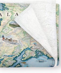
Alaska State Map Fleece Blanket
Introducing the Utah State Map Blanket by Xplorer Maps – a cozy tribute to Utah’s rugged beauty and rich heritage. Crafted from 50% Berber fleece and 50% microfiber fleece, it offers unmatched softness and durability.
Size: 58″ x 50″Material: 50% Berber fleece, 50% microfiber fleeceDesign: Detailed map of Utah highlighting cities, landmarks, and local flora and faunaCare: Machine washable below 85°F (avoid tumble drying and ironing)


MORE THAN MAPS


Alaska State Map Puzzle
Art and fun all in one! The 1000 piece Xplorer Maps’ Alaska State MAP ART puzzle is made from the highest-quality recycled blueboard and is an exact replica of our unique, hand-illustrated artistic map exclusively designed and illuustrated by Xplorer Maps artist and co-founder, Chris Robitaille. These map art puzzles make perfect gifts and souvenirs for the traveler, nature-lover or national park enthusiast and can be framed for permanent display. Each puzzle is packaged in a classy display box and includes a 20″ x 15″ reference poster for easy reference and happy puzzling.
Alaska State Map Canvas Tote Bag
When “Xploring” requires some toting – consider doing it in style with our Xplorer Maps reusable canvas tote bags. Generously sized at 18″ wide by 15″ tall, they’ll pack enough for a day at the beach; a trip to the grocery store; or a day at the local Farmer’s Market. Goodbye single-use plastic bags – now can take your favorite place with you again and again.
Alaska State Map Ceramic Mug 16 oz
Alaska State Map Mugs by Xplorer Maps are designed by illustrator and co-founder Chris Robitaille. With a capacity of 16 ounces each, these ceramic, BPA-free mugs are perfect for your favorite beverage. Whether you love national parks, enjoy maps, or have visited these amazing locations, these are the perfect gifts for you.
Alaska State Hand-Drawn Map
While known for its diverse terrain of open spaces, amazing scenery, recreational activities, and small towns nestled into incredible landscapes, it is North America’s highest peak: Denali at 20,310 feet and the truly magnificent wildlife that captures our hearts and sparks our sense of adventure. From the soaring eagles and lounging puffins to the roaming grizzlies, polar bears and wolves to the sea-faring whales, sea lions and dolphins, whether by air, land or sea it would be hard to experience all of Alaska in a single lifetime. Xplorer Maps will donate a portion of all proceeds from the sale of this map to Alaska Geographic, one of our growing list of Public Lands Alliance partners.
The Alaska State Map is 24″ wide by 18″ tall.
Our Story
The Xplorer Maps journey began in 2010 with two brothers – a talented, globe-trotting artist and an entrepreneurial geographer and outdoor enthusiast – who had a mission to create uniquely hand-drawn, antique-styled story maps of national parks and travel destinations. Their mission was to help create lasting and meaningful connections between people and places.
Sixty-plus illustrated maps later, the Robitaille brothers (with unwavering support from their most amazing partners; Julie and Ness) have found their stride. Storytelling and engagement through art has become their mantra. With a growing collection of accompanying map products, the options are limitless to help provide high-quality and special memories for your family and friends.


About the Artist: Chris Robitaille
Chris Robitaille was born in Toronto, Canada, and graduated from the Ontario College of Art where upon graduation, he was awarded the Will Davies Award for Excellence in Illustration. His work in Toronto as a storyboard artist gave him a strong understanding of the importance of competent drawing and sound composition, elements that have been an integral part of his work over the years. Chris moved to Kenya in the early 1990s, turning his attention to landscape and wildlife oil painting. He has had dozens of solo exhibitions and his work hangs in numerous corporate and private collections worldwide. Since 2007, Chris, his wife Vanessa, and their children Max and Becca have lived in Suzhou; Abu Dhabi; Bangkok; and most recently Doha following a professional career in Ness in international education. The Xplorer Maps business and family adventures continue with regular visits back home to Toronto and Montana.


PHILANTHROPY-GIVING BACK FOR OUR PUBLIC LANDS – As members of 1% For The Planet, Xplorer Maps donates a percentage of proceeds from every product we sell to a variety of non-profit organizations around the world. All of these organizations have similar missions as we do; focused on the conservation, preservation, and education of our Public Lands. To date, Xplorer Maps has donated more than $100K to more than 37 different organizations since we began 10 years ago.
WARMTH FOR ALL SEASONS – Our Fleece Blanket is soft, comfortable, and breathable. A 50-50 of microfiber and Berber fleece, will keep you warm during cold nights and chilly days. Great to use at the home, cabin, in your dorm room away from home; or even outdoors!
HIGH-QUALITY MATERIAL – We use 50% Berber fleece and 50% microfiber fleece to make our soft, comfy, and gorgeous fleece blanket. Berber fleece is a luxurious, high-performance fabric that is extremely warm, soft, and lightweight. A microfiber fleece is a 100% polyester fabric with moisture-wicking properties and is soft to the touch.
UNIQUE DESIGN – Beautifully hand-illustrated story map blanket with vibrant colors and a unique design. Every line, letter, and icon is unique, custom, and original to each new map we render. This custom map series was designed and rendered by Chris Robitaille (Xplorer Maps artist and co-owner) in an antique, old-world style in tribute to early cartographers.
PERFECT GIFT IDEA – At Xplorer Maps, we strive to make meaningful connections between our hand-drawn “story” maps and your personal travel and life experiences. Surprise your family, friends, neighbors, business colleagues, or loved ones. The perfect gift for map lovers, history and geography buffs, travelers, and teachers. Also becoming super popular as Home Decor for your VRBO or Airbnb rentals.


